|
| | Map of Little House Set |  |
| | | Author | Message |
|---|
Toby
New Pioneer


Number of posts : 239
Location : Michigan
 |  Subject: Map of Little House Set Subject: Map of Little House Set  Mon Jul 07, 2008 10:59 pm Mon Jul 07, 2008 10:59 pm | |
| I often see people on forums asking where Little House was filmed, if the buildings are still there, and if there is a map of the set. It was mostly filmed at Big Sky Ranch in Simi Valley, California. Unfortunately, none of the original buildings are still standing. I found the location of the Little House set on Google maps a while ago, and with the help of a diagram that Eric Caron sent me, I recently created a Google map of Walnut Grove and placed icons where it looked like the various buildings and houses were. Check it out, and feel free to send me corrections and better icons to use. The following link will take you to the part of the map with the town. http://maps.google.com/maps/ms?ie=UTF8&hl=en&t=h&msa=0&msid=109369061282146989841.0004517631015be52143f&ll=34.326023,-118.736745&spn=0.001026,0.001663&z=19 You can zoom in and out on this map. Click on each icon to see what it is supposed to be. Follow Middle Ridge Fire Rd down and to the right and you will see more houses and buildings until you get to the Ingalls house. The Ingalls house was almost a mile east of town. The map also gives you an option to open up the location in Google Earth. You won't find the covered bridge on the Simi Valley set, because even though it was portrayed as being part of Walnut Grove, it is actually located at Disney's Golden Oak Ranch about 16 miles to the east of Simi Valley. You can view that at the following link. http://maps.google.com/maps/ms?t=h&hl=en&ie=UTF8&msa=0&ll=34.378378,-118.477617&spn=0.001025,0.001663&z=19&msid=109369061282146989841.0004517a3be3869ca2b2aBelow is an embedded map that allows you to zoom and scroll. View Larger MapThe following is a screen capture from a portion of the map. 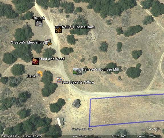
Last edited by Toby on Tue Jul 08, 2008 3:52 pm; edited 1 time in total | |
|   | | bethandmanly
Dean's Dedicated Diva


Number of posts : 7600
Location : In a book
Mood : 
 |  Subject: Re: Map of Little House Set Subject: Re: Map of Little House Set  Mon Jul 07, 2008 11:25 pm Mon Jul 07, 2008 11:25 pm | |
| This is really neat. I think I've seen this before, but it's always nice to have it around. You know what I would really like to see is where the Little House on Plum Creek, the Wilder farm, the Edwards' place, the Garveys' farm, and Hanson's house are in relation to this map. I can't always get a feel for how they got to and from their houses from the show.
I was just talking about the episode, "He Loves Me, He Loves Me Not" the other day, and when Laura and Almanzo meet up the morning that he decides to leave Walnut Grove, Almanzo comes over a covered bridge. I can't place that bridge or why he would be traveling over it, since you don't usually see him traveling over a bridge in other episodes. A map of where those farms are would help me get the whole picture.
Thanks for sharing this. | |
|   | | Toby
New Pioneer


Number of posts : 239
Location : Michigan
 |  Subject: Re: Map of Little House Set Subject: Re: Map of Little House Set  Tue Jul 08, 2008 4:43 am Tue Jul 08, 2008 4:43 am | |
| Did you click the first link? You can follow the main road out of town by scrolling to the right and you will go past the pond, blind school, Wilder farm, Edwards/Garvey place etc, all the way to Plum Creek. I'm not sure where Hanson's house was though. According to Eric's diagrams, the Edward's place and Garvey farm were at the same location. The blind school is next to the pond, and the Wilder farm is across the street from the blind school. Zoom out until you see a barn and house off to the right away from every thing else and that is the Ingall's place. I'm not sure where the covered bridge is supposed to be in town, but being 16 miles away in real life is why we don't see it in every episode. I think in the story line, Plum Creek is three miles away from town even though it is a little under a mile on the actual set. | |
|   | | Rhonda
Prairie Survivor


Number of posts : 21216
Location : On my bike!!!
Mood : 
 |  Subject: Re: Map of Little House Set Subject: Re: Map of Little House Set  Tue Jul 08, 2008 10:27 am Tue Jul 08, 2008 10:27 am | |
| | |
|   | | bethandmanly
Dean's Dedicated Diva


Number of posts : 7600
Location : In a book
Mood : 
 |  Subject: Re: Map of Little House Set Subject: Re: Map of Little House Set  Tue Jul 08, 2008 10:45 am Tue Jul 08, 2008 10:45 am | |
| - Toby wrote:
- Did you click the first link? You can follow the main road out of town by scrolling to the right and you will go past the pond, blind school, Wilder farm, Edwards/Garvey place etc, all the way to Plum Creek. I'm not sure where Hanson's house was though. According to Eric's diagrams, the Edward's place and Garvey farm were at the same location. The blind school is next to the pond, and the Wilder farm is across the street from the blind school. Zoom out until you see a barn and house off to the right away from every thing else and that is the Ingall's place. I'm not sure where the covered bridge is supposed to be in town, but being 16 miles away in real life is why we don't see it in every episode. I think in the story line, Plum Creek is three miles away from town even though it is a little under a mile on the actual set.
Aha! Found it. Thanks. I didn't see Plum Creek, but maybe that's because I didn't go slow enough. The Blind School was supposedly Hanson's old house--which burnt down in "May We Make Them Proud", but was miraculously resurrected in Season 9 for "Welcome to Olsenville". Thanks for doing this. It's a great resource.   | |
|   | | Toby
New Pioneer


Number of posts : 239
Location : Michigan
 |  Subject: Re: Map of Little House Set Subject: Re: Map of Little House Set  Tue Jul 08, 2008 3:34 pm Tue Jul 08, 2008 3:34 pm | |
| - Rhonda wrote:
-
 Thanks for sharing that with us Toby, and mostly thanks for taking the time out to do so much research and put in the time it had to take place all the buildings and all. It does put things into more perspective when you know which direction you are headed in.......Seems like on the show, the town was much closer to each other, but when viewed on the map, it was quite spread out...... :think: Thanks for sharing that with us Toby, and mostly thanks for taking the time out to do so much research and put in the time it had to take place all the buildings and all. It does put things into more perspective when you know which direction you are headed in.......Seems like on the show, the town was much closer to each other, but when viewed on the map, it was quite spread out...... :think: No problem. I thought it would be fun to do and Google Maps and the info Eric Caron emailed me made it kind of easy. It's hard to do the buildings to scale because the icons stay pretty much the same size no matter how close you zoom in or how far you zoom out. Most of the buildings roofs should be about the same size as a tree top, but they are only about the size of half a tree top or less at the zoom level I put the map to. Everything in town was pretty close, it just appears spread out because I have it zoomed in so close. Most of the town would fit on a football field. The church, mercantile, and restaurant are all within 100 feet of each other, and the distance between the church and Doc Baker's office is only about 90 yards. The white outline in the picture below is approximately the size of a football field including the end zones. 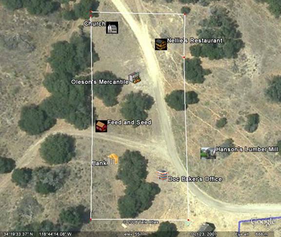 | |
|   | | Guest
Guest
 |  Subject: Re: Map of Little House Set Subject: Re: Map of Little House Set  Tue Jul 08, 2008 3:47 pm Tue Jul 08, 2008 3:47 pm | |
| Thanks for posting the maps Toby. The buildings do look closer in the show. |
|   | | Lily
"Beautiful Life"


Number of posts : 6784
Location : In the town shopping
Mood : 
 |  Subject: Re: Map of Little House Set Subject: Re: Map of Little House Set  Wed Jul 09, 2008 10:45 pm Wed Jul 09, 2008 10:45 pm | |
| Wow! Thank you for posting this, Toby, this is really cool! I didn't realize how far it is between the church and the Hanson's Mill. When I watch Charles working at the mill, seems like the church/school is right across the street from it, but from this map, it seems so far away.  "Within the heart of every stray, lies the singular desire to be loved." "Within the heart of every stray, lies the singular desire to be loved." | |
|   | | carolineingalls
Farm Land Owner


Number of posts : 1209
Location : Northern Ireland
Mood : 
 | |   | | ChristinaAL
Little House Lady


Number of posts : 2761
 |  Subject: Re: Map of Little House Set Subject: Re: Map of Little House Set  Sat Jul 12, 2008 3:09 pm Sat Jul 12, 2008 3:09 pm | |
| | |
|   | | mcfair_58
New Pioneer


Number of posts : 8
Location : Southwest Ohio
Mood : 
 |  Subject: Maps - thanks! Subject: Maps - thanks!  Tue Jul 12, 2016 12:07 pm Tue Jul 12, 2016 12:07 pm | |
| Thanks for the map. I am writing Little House fan fiction and it really helped! | |
|   | | Sponsored content
 |  Subject: Re: Map of Little House Set Subject: Re: Map of Little House Set  | |
| |
|   | | | | Map of Little House Set |  |
|
Similar topics |  |
|
| | Permissions in this forum: | You cannot reply to topics in this forum
| |
| |
| |
